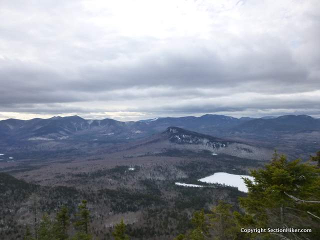
Mt Tremont (3371′) is a picturesque 3000 footer in Crawford Notch overlooking Sawyer Pond, Greens Cliff, and the Sandwich Range to the south. It's a relatively short (2.8 mile) but steep hike (2550′ of ascent) up to the summit viewpoint. You can also approach the peak from the south on the Brunel Trail, climbing a NH200 peak called Owl's Cliff, with a short detour. But that's a hard trail to hike in winter because it has a major stream crossing at the very beginning.

I've climbed Tremont many times before, but this time I was interested in checking out the stream which runs along the base of the trail and seeing if I could find an old logging road that intersects the trail part way up. There are all kinds of things marked on White Mountains maps which are out of date or plain wrong. I figured it would be fun to follow this logging road sometime in the future if I could figure out where it was. I've also teaching a few map and compass classes this spring and wanted to scout this area as a possible spot to run some class exercises. It's not in a Wilderness Area, which means you can bring more than 10 people into it at a time. I'm a hopeless romantic, I guess, and still adhere to those rules.

I quickly put on my microspikes at the bottom of the trail and hiked up to the intersection of the logging road. It was overgrown and obviously out of use, but you could still see where the track is despite the fact that the trees have grown in on top of it. I can understand why that road is still on this map: it's an old USGS map published before 1990 back when all USGS maps were drawn by hand, making updates very difficult (so they didn't). Who knows? Maybe that forest road was is service 30 years ago when this map was considered reasonably current.
This is just another example of how you can't trust all of the human structures you find on maps. Topographic contours are pretty reliable because the shape of landscape changes quite slowly. But backcountry bridges get swept away in spring floods, logging roads fall into disuse and return to the forest, trails are rerouted around avalanche zones or to control erosion, and so on. But I digress.
Nearby hikes
- Hiking an Attitash Trail Traverse
- Bushwhacking Greens Cliff
- Short Hikes in the Whites: Mt Crawford, Mt Martha and Owlshead
- Backpacking the Livermore Loop
After the logging road, the trail got wet and muddy before dropping down to a stream crossing across Stony Brook. I switched to snowshoes and started climbing the final mile to the summit. The snow was the consistency of mashed potatoes in the warm weather. The trail was also heavily postholed (sigh) by people who hadn't been wearing snowshoes. I can never understand this. It's dangerous to posthole in deep snow because you can easily break a leg. It ruins the trail for others and it takes infinitely more energy to climb a mountain while postholing.
Cursing the postholers, I climbed up that last mile and approximately 1500′ of elevation gain at a slow but steady pace. I hoped my snowshoe tracks would pack out the trail for people following me. The top of the Mt Tremont Trail is so steep that it has switchbacks, which are quite rare in the White Mountains. I topped out finally and met to other hikers on the summit, who has also been wearing snowshoes. Good thing that, because I'm not sure I could have held my tongue if they'd been postholers.
We chatted briefly, the way that people do at a viewpoint. I drank some hot tea and headed down again fairly quickly since there was a cool breeze above treeline. My snowshoes had in fact filled in most of the postholes on the narrow trail, which I found satisfying. The descent was much less arduous than the climb and I scouted Stony Brook a little bit more closely on the way out. There's definitely excellent trout habitat there.
Total distance: 5.6 miles with 2550′ of elevation gain.
Recommended Guidebooks and Maps:
- Appalachian Mountain Club White Mountain Guide, 30th ed.
- AMC White Mountain National Forest Map Set
- White Mountains Map: New Hampshire and Maine
Support SectionHiker.com, where we actually field test the products we review. If you make a purchase after clicking on the links above, a portion of the sale helps support this site at no additional cost to you. |
The post Climbing Mt Tremont in January appeared first on Section Hikers Backpacking Blog.
from Section Hikers Backpacking Blog http://ift.tt/2BvlPOz
No comments:
Post a Comment