Thursday, May 31, 2018

Howker Ridge Loop Trip Plan: Backpacking the White Mountain 4000 Footers Guidebook

The Howker Ridge Loop Trip Plan

The Howker Ridge Loop is a 2 day, 18 mile loop that climbs all of the peaks in the Northern Presidential Range: Mounts Madison, Adams, and Jefferson. The route passes several unusual geological features including small peaklets known locally as Howks, an alpine tarn called Star Lake, and towering rock spires called castles. After climbing Madison and Adams, we recommend spending the night at one of the Randolph Mountains Club's huts or campsite, close to treeline. The next day begins with a short hike to Edmands Col before climbing Mt Jefferson and then a looping descent past numerous waterfalls to the valley below.

Howker Ridge Loop

Rating/Difficulty

*****/4 out of 5

Distance/Elevation Gain

18 miles w/6600′ of cumulative elevation gain

White Mountain 4000 Footers

  • Madison
  • Adams
  • Jefferson

Recommended Duration

2 days

Season

June thru October

Permits Required

None.

Regulations

Backcountry Camping Regulations for the White Mountain National Forest.

New to the White Mountains? Read this Quick and Dirty Guide to Backpacking in the White Mountains for information about camping regulations, road access, trail shuttles, lodging, dangerous wildlife, weather, etc.

Weather Cautions

This route is sensitive to seasonal weather which can make it hazardous. Most of this route is above-treeline and travels across exposed terrain where high wind, cold temperatures, fog, thunderstorms, lightning, and hail storms are common during the summer months.

Above-treeline warning sign

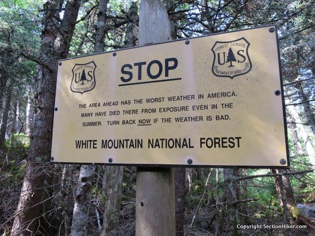
The best way to avoid difficulties or injury is to time your hike to avoid poor weather (by checking the Weather.gov and Mt Washington Observatory Higher Summits Forecasts) and to bring proper clothing, equipment, and navigational aids. If you're inexperienced with above-treeline backpacking, I'd also recommend bringing a more experienced friend or guide to show you the ropes.

Trailhead Directions

  • Randolph East Trailhead; easiest access is from Rt 2, just south of the Appalachia Trailhead. Turn left onto Pinkham Notch 'B' Rd and look for the parking lot on your right.

Trail Sequence

The route follows the following trails in sequence. Refer to the AMC White Mountain Trail Map 1: Presidential Range  (2017 ed), which is the best waterproof map available for this region, although I'd recommend buying the complete AMC White Mountain Waterproof Map Set (2017 ed) rather than one map at a time, because it's less expensive that way. More detailed trail descriptions can be found in the AMC White Mountain Guide (2017 ed), which is considered the hiking bible for the region. Take photos of the relevant pages using your phone for easy reference, instead of carrying the entire book with you on hikes.

  • Howker Ridge Trail – 4.1 miles
  • Osgood Trail – 0.8 miles
  • Star Lake Trail – 1.o miles
  • Lowes Path – 1.2 miles
  • Gray Knob Trail – 1.2 miles
  • Randolph Path  – 0.7 miles
  • The Gulfside Trail  – 0.2 miles
  • Jefferson Loop – 0.3 miles
  • Castle Trail – 1.5 miles
  • The Link – 5.0 miles
  • Sylvan Way  – 1.0 mile
  • Randolph Path – 0.7 miles

Scenic Highlights

The following list provides cumulate distances on the route to each view or landmark

  • First Howk – 2.7 miles
  • Fourth Howk – 3.5 miles
  • Mount Madison Summit – 4.4 miles
  • Madison Hut – 4.9 miles
  • Star Lake – 5.2 miles
  • Mt Adams Summit – 5.9 miles
  • Thunderstorm Junction – 6.2 miles
  • Mt Abigail Adams (Adams 4) -6.6 miles
  • Gray Knob Cabin & The RMC Camps – 7.4 miles
  • Edmands Col – 9.3 miles
  • Mt Jefferson Summit – 9.6 miles
  • The Castles – 10.6 miles
  • Cold Brook Falls – 16 miles

Camping and Shelter Options

Water

Natural water sources are plentiful in the White Mountains although you may need to descend to them from ridgelines along side trails if you run short. In any case, carry a detailed topographic map with you and don't rely on the overview map provided with this trip description to find water sources.

I also recommend purchasing the WMNF Presidential Range Map in Guthook Guide's New England Hiker Smartphone App (IOSAndroid) which is a GPS guide to all of the trails, trailhead, shelters, campsites, views, and water sources in the White Mountains National Forest. I use it all the time and it is much more complete and current than using the maps bundled with the Gaia Smartphone App.

On the Trail

This route starts at the Randolph East parking lot, which is down a short side road called Pinkham B, just east of the famous Appalachia Trailhead on Rt 2. At the trailhead, follow signs for the Howker Ridge Trail, which runs through hardwoods and past several small waterfalls before it begins to climb up the east ridge of Mt Madison. The RMC or Randolph Mountain Club maintains many of the trails and shelters that you'll use on this hike. They're a small local club with a storied history of trail building in the Northern Presidentials and worth supporting. You also get a much reduced nightly rate at their shelters and camps if you're a member (click for membership).

Howker Ridge Trail

After passing several waterfalls and cascades, the Howker Ridge Trail begins climbing the northeast ridge of Mount Madison with many ups and downs. There are four howks as they're called, or peaklets on the ridge, which are look like rounded humpish hills, when you're looking down on the trail from above.

Howk on the Howker Ridge Trail

The first of these occurs after 2.3 miles and the second at 3.0 miles. The Pink Link Trail joins the Howker Ridge Trail on the left and the two coincide for 0.3 miles, climbing to the third howk which has a good view of Madison. The two trails diverge again and the Howker Ridge Trail continues to climb, passing the fourth howk at mile 3.5 (4315′). The trail soon ascends above treeline where it is completely exposed to the wind and weather. Continue climbing, before turning SW onto the Osgood Trail which follows the ridgeline over the Mt Madison summit.

Osgood Trail, Mount Madison

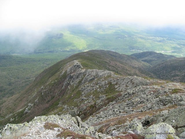
The view  from Mt Madison is quite spectacular and affords descent wind protection if you hunker down behind the rocks near the summit sign. Looking to the southeast, you should see a long, curving, boulder-covered ridge descending to Pinkham Notch. This is also the Osgood Trail, but headed in the opposite direction from where you'll be going. Turning to the southwest is Mt Adams, the second highest mountain in the Whites, on the other side of the Madison Col. Beyond that in the distance, you can just make out Mt Jefferson as well.

Summit Cairn on Mt Madison - Mt Adams looms nearby, the next peak on the ridge
Summit Cairn on Mt Madison – Mt Adams looms nearby, the next peak on the ridge

From the Madison summit sign, follow the Osgood Trail west to the AMC's Madison Springs Hut. Located in the col between Madison and Adams, the hut is a good place to top off your water bottles, use the rest room, or buy a snack. Day hikers are welcome to come inside even if they're not overnight guests. The hut is also a good place to check on the wind speed, barometer, and latest forecast, which is updated every morning.

A restorative bowl of soup at the AMC's Madison Spring Hut

From the hut, follow the Star Lake Trail a short distance passing a small alpine tarn (pond). While it usually has some water in it, the level varies by season and weather conditions. Bear right past the tarn and continue following the Star Lake Trail which scrambles, steeply at times, to the summit of Mt Adams. When you crest the peak, be prepared for a blast of wind from the prevailing northwesterly prevailing winds that scour this exposed summit. Like Madison, the views from Adams are sublime. Look down into the Great Gulf, the great glacial cirque at the foot of the northern Presidentials ,and across it to "George", as Mt Washington is known locally.

Hike past Star Lake, before scrambling up the south face of Adams to the summit

From the Adams summit, follow the Lowes Path for 0.3 miles across a boulder field to the huge cairn at Thunderstorm Junction, which is visible below in clear weather. This section of the Lowes Path is marked with rock cairns and must be followed carefully.

Thunderstorm Junction, White Mountains

When you arrive at  Thunderstorm Junction, I'd recommend calling it a day and heading down below treeline to stay at the RMC's Gray Knob or Crag Camp Self-Service Cabin or The Perch Tentsite for the night. All three of these options are far less expensive than staying in the AMC's Mountain Springs Hut, but are also self service.

Randolph Mountain Club's Crag Camp Cabin

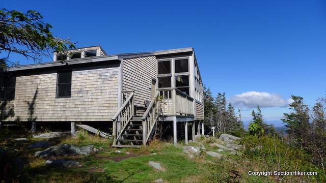
Gray Knob is a pleasant self-service hut to stay at overnight with mattresses on the floor and a small eating area. The RMC's Crag Camp, a similar hut, is a short walk. If you prefer to camp, the RMC's The Perch Campsite has a three-sided lean-to and tent platforms that are also available.  All require payment of a small overnight fee, and now accept Paypal, in addition to cash. See the shelter description links above for details.

Mt Abigail Adams, also known as Adams 4

All of the RMC Huts and Campsites can be reached by continuing along the Lowes Path for 1.2 miles. This trail is marked by quartz-topped cairns and best hiked in daylight. There is a small rock scramble 0.3 miles below Thunderstorm Junction over a sub-peak of Mt Adams called Mt Abigail Adams (also called Adams 4 on older maps), before the trail continues to a junction with the Gray Knob Trail and The Perch Path.  Both the Gray Knob and Crag Camp Cabins are located along the short Gray Knob Trail, while the Perch Path leads to The Perch lean-to and tent site platforms.

Camping at The Perch

Resume the next morning by following the Perch Path almost due south, towards Mt Jefferson. Turn left at the Israel Ridge Path Trail Junction. In 0.4 miles, the Israel Ridge Trail meets the Randolph Path, and the two trails coincide for 0.1 miles. Continue along the Randolph Path for another 0.7 miles until its junction with the Gulfside Trail in Edmand's Col, a sheltered windbreak in the lee of Mt Jefferson.

Edmands Memorial Plaque

Once the site of a rescue cache, Edmands Col has a plaque dedicated to J. Rayner Edmands, one of the great trail architects of the interconnected White Mountain Trail system. When hiking in the Northern Presidentials, you can still see evidence of his handiwork today. A stickler for precision, he built many of the major trails using carefully fitted stones, so they're easy to follow across the rough, rock-strewn terrain.

Large rock cairn just below the Jefferson summit

From Edmands Col, turn right onto the Gulfside Trail (bearing southwest) and follow it for 0.2 miles, turning right onto the Jefferson Loop Trail. Follow it for 0.4 miles, passing a large rock cairn, just below the summit which is a short scramble to the summit sign. Jefferson is one of the windiest spots in the Whites, short of the Mt Washington summit, so hold onto your hat, lest it blow into the Great Gulf.

Descend to the large rock cairn, following the Jefferson Loop Trail to the Castle Trail, which runs down the mountain's north side. Like the Howks, the Castle Trail is topped by rocky outcroppings known as castles, which tower above Castle Ravine below. There are two castles, just below 4500′ of elevation.

Castle on the Castellated Ridge below Mt Jefferson

You'll dip below treeline after the second castle, near "The Link" trail junction. Turn right onto The Link, which is a long looping descent around the back of the Northern Presidential range. It passes through hugely varied terrain, beginning with steep descents, waterfalls, and several easy water crossings, followed by forested hardwoods. The Link is fairly well blazed and easy to follow, but seldom hiked by day hikers, so less heavily used than the trails running up to the peaks.

Follow The Link for 5.3 miles, passing many trail junctions, until you cross over the pretty wooden Memorial Bridge, below Cold Brook Fall. Jog right onto the Sylvan Way, a pretty forested path for 1.0 mile, before turning left onto the Randolph Path for the remaining 0.7 miles back to the Randolph East parking lot and the end of the route.

About Philip Werner: Philip is the 36th person to finish hiking and backpacking all of the trails in the White Mountain Guide. He's also finished hiking many of the region's peakbagging lists including the White Mountain 4000 footers, the 4000 footers in Winter, the Terrifying 25, the RMC 100, and the Trailwrights 72. Philip is a 4 season backpacking leader for the Appalachian Mountain Club, a member of the executive committee for the Random Hikers, a Long Trail Mentor for Vermont's Green Mountain Club, and a Leave No Trace Master Educator. He also teaches several compass, GPS, and off-trail navigation courses each year, listed on Outdoors.org.

Safety Disclaimer

This trip plan can not alert you to every hazard, anticipate your experience, or limitations. Therefore, the descriptions of roads, trails, routes, shelters, tent sites, and natural features in this trip plan are not representations that a particular place or excursion will be safe for you or members of your party. When you follow any of the routes described on SectionHiker.com, you assume responsibility for your own safety. Under normal conditions, such excursions require the usual attention to traffic, road and trail conditions, weather, terrain, the capabilities of your party, and other factors. Always check for current conditions, obey posted signs, and Backcountry Camping and Wilderness Area Regulations. Hike Safe and follow the Hiker responsibility code. 

Published 2018.

SectionHiker.com receives affiliate compensation from retailers that we link to if you make a purchase through them, at no additional cost to you. This helps to keep our content free and pays for our website hosting costs. Thank you for your support.

The post Howker Ridge Loop Trip Plan: Backpacking the White Mountain 4000 Footers Guidebook appeared first on Section Hikers Backpacking Blog.


from Section Hikers Backpacking Blog https://ift.tt/2snATw9

601 Beach Crescent in Vancouver

601 Beach Crescent by Pinnacle International is a new 52-storey highrise development located on the east side of the Granville Street Bridge, in Downtown Vancouver. The proposal calls for approximately 300 market homes within the tower, plus a large lot-spanning podium with 152 non-market housing units, with a total square footage of 126,710 square feet. The non-market housing unit mix is 13% studios, 50% one-bedroom, 20% two-bedroom and 16% three-bedroom.

The post 601 Beach Crescent in Vancouver appeared first on Vancouver New Condos.


from Buildings – Vancouver New Condos https://ift.tt/2svqPAv

Wednesday, May 30, 2018

New Hampshire Appalachian Trail Section Hike: Hanover to Wentworth

Lambert Ridge on the New Hampshire Appalachian Trail

The New Hampshire Appalachian Trail begins at the bridge over the Connecticut River that separates Vermont and New Hampshire. That's where I had my shuttle driver drop me off, before I headed up the hill thru Hanover Center, which was bustling with Dartmouth students. A few turns along some side streets and I entered the western end of the White Mountain National Forest, headed east on the Appalachian Trail.

Most people don't realize that the Whites begin in Hanover, which is 50 miles west of Mount Moosilauke, the first of the 4000 footers that thru-hikers have to climb on their way to Maine. All of the maps for the White Mountain National Forest leave out all of the trails west of Moosilauke, including those published by the Appalachian Mountain Club, although the descriptions and driving directions for them are included in the White Mountain Guide.

Most people don't realize how far west the White Mountain National Forest extends
Most people don't realize how far west the White Mountain National Forest extends, as far west as Hanover on the Vermont/New Hampshire State Line.

While I've already section hiked the entire New Hampshire Appalachian Trail before, I picked this route because it was snow free.  Backpacking in May, east of Glencliff, NH (the west side of Mt Moosilauke) can be a real challenge, because lingering snow makes many of the higher elevation trails impassable until Memorial Day, and some stay that way into July. Your best bet is to stick to trails under 3000′ in elevation, at least if you want to avoid carrying snowshoes and microspikes.

The section of the AT east of Hanover resembles a popular town park, more than a wilderness trail. You soon come to the Velvet Rocks Shelter right outside of town. Being so close to civilization, it's heavily used, and it looked like someone had been living there when I visited. The shelter area is on a loop off the main trail, which I followed (all the way around) before continuing east. I was interested in hiking all of the little side trails on this trip, mainly to the shelters, as well as the main trail.

Wetlands Bridge
Wetlands Bridge

It'd been about 10 years since I'd hiked through this area and I'd forgotten what many sections of the trail looked like. Except for the shelters and a few landmarks, like mountain summits, I felt like I was hiking the trail for the first time. Given the frequent reroutes made to the Appalachian Trail, I might well have been.

As I travelled east, the road crossings became less frequent and the wooded sections longer. I'd gotten a late start that morning, when my shuttle driver had arrived late due to engine trouble. That meant I was only going to make it to the Moose Mountain Shelter that evening, instead of hiking a few miles farther. On hindsight, I'd wished I had hiked farther because the water source at Moose Mountain was pathetic, just a trickle. There is a great stream farther down the trail, to the east of North Moose Mountain, where I wish I had camped. But somehow there's psychological comfort in camping at the shelters and their tent sites, which is why people tend to spend the night at them rather than camping wild in the surrounding woods.

The famous Moose Mountain Privy without walls

I pitched my hammock, ate dinner, and crashed early as is my habit. It was a windy night, but I was snug as a bug in my Warbonnet Wookie. This being a 2-night, mid-week hike, I didn't share the shelter areas with anyone and hardly saw anyone on the trails. Kind of how I like it, to be honest, because it gives me time to think and remember what I'm experiencing rather than chatting away obliviously. There's a time for social hiking and a time for solitary hiking, and I was in the mood for the latter. This hike was going to be a short respite from worldly concerns and savored while it lasted.

The New Hampshire AT follows an established local trail system

While the AT is well-marked when you get into the White Mountains, it does follow an existing trail system. This can be confusing to thru-hikers and local alike, since the AT follows a sequence of differently named trails that start and end every few miles. These local trail names are left out of David Miller's AT Guide and Guthook's Guide (smartphone) which can add to the confusion. In the eastern half of the Whites, AT thru-hikers often cross out the local trail names on signs with sharpie pens or carve out their names with knives, for reasons that I don't care to guess at (See Appalachian Trail Sign Defacements.) Thankfully, these signs remained undisturbed.

Smarts Mountain, far to the south

After leaving the Moose Mountain Shelter, I hiked from South Moose to North Moose Mountain, along a lovely section of the AT, stopping at Holt's Ledge to admire the view of Smarts Mountain, well to the south. Smarts is a big hill that I'd climb later in the day, requiring 2000′ of elevation gain. That's not a huge amount of elevation gain by itself, but it was going to be a big day.

Trapper John Shelter Fireplace

I hiked down to the Trapper John Shelter, a short distance off the main AT, to resupply my water. There's a giant stone fireplace in front of the shelter and a small camping area behind it. The trail down to the shelter had some big blowdowns blocking it, so I guess the trail maintainers haven't been out yet.

Maggie poses at the milepost
Maggie poses at the mile post

I soon passed the 412 mile marker (that's 412 miles remaining for NOBOs) before reaching the base of the climb to Smart's Mountain. This climb has two parts. There's the climb up to Lambert's Ridge on the west side of the mountain that has the great views (see top photo) from a series of exposed ledges. The trail plateaus after the ledges before climbing very steeply again to the summit over iron ladders fused into the rock ledges.

Fire Warden's Cabin on Smarts Mountain, NH
Fire Warden's Cabin on Smarts Mountain, NH (from a Nov 2016 trip)

No big deal. I made it up to the Smart's summit and had a snack on the bench besides the fire warden's cabin, which is open and can be used as a shelter by hikers. The cabin water source was flowing well when I was there, and I refilled my bottles for the next leg of my hike. There's also a fire tower at the summit, which I confess, I've never bothered to climb. I have camped up here before (this was my third ascent of the peak), but planned to continue to Mt Cube and the shelter there for the evening.

South Jacobs Brook at the base of Smarts Mountain

The hike down the back of Smarts was longer than I'd remembered, but there was now a sturdy wooden bridge across Jacobs Brook and not the intimidating rock hop that I remembered from a decade earlier. This is a lovely stream, worth coming back for some swimming and Tenkara, sometime. I'd intentionally left my rod and tackle at home for this trip though, so as not to be tempted by too many long detours.

The unique six-sided Hexacuba Shelter
The unique six-sided Hexacuba Shelter.

I was pretty tuckered out by this point, but wanted to hike another 1.5 miles to the Hexacuba Shelter, a six-sided shelter, on the south side of Mt Cube. This was shaping up to be a respectable 17.5 mile day with over 4000 feet of elevation gain. I girded myself up the next 500′ of elevation gain, climbing the Eastman Ledges on the Kodak Trail, (naturally) before arriving at the shelter.

The Penta Privy is a five-sided outhouse

It took me a while to find a good place to pitch my hammock in the vicinity of the shelter, because there were so many widow-makers from the winter. I ate dinner once I'd gotten situated and propped up my water filter so it wouldn't freeze that night (a frost was forecast), before falling into a peaceful sleep. The trick is to leave your water filter (a Sawyer Squeeze) connected to a Platypus and suspended in a gravity filter configuration, so that the interior remains in contact with liquid water. The water will get cold, but it doesn't freeze, so your filter remains undamaged. Whereas, if you just store your water filter damp, there's a greater chance that it will frost up inside and be destroyed.

I slept in the next morning and only broke camp by 8:00 am. It was a short, but steep climb to the summit of Cube, which is a far more magnificent peak than Smart's though not as high. Topped by open ledges, you can see for miles from the summit. I hiked along the summit spur trail to North Cube and admired the view from the ledges there, before descending down the north side of Cube and the end of this short section.

Hanover to Wentworth NH on Appalachian Trail

Total distance: 33 miles with 8500′ of elevation gain (Click to Download GeoPDF map)

The post New Hampshire Appalachian Trail Section Hike: Hanover to Wentworth appeared first on Section Hikers Backpacking Blog.


from Section Hikers Backpacking Blog https://ift.tt/2J0Zzkl

Cedar Creek in the heart of South Burnaby

Ledingham McAllister is excited to announce the launch of Cedar Creek, coming soon to the heart of South Burnaby. Inspired by the majestic Cedar, these six-storey, wood-frame residences embody West Coast design and convenient living in the established Edmonds neighbourhood. A fresh new community within walking distance of shopping, education, entertainment, recreation, SkyTrain, and every conceivable amenity for easy and active living.This beautiful collection of 1 bedroom and den to 3 bedroom homes, ranging in size from 635 to 995 sq.ft., all boast overheight ceilings, open floor plans, premium appliances and extensive glazing for the brightest and most livable of homes.

The post Cedar Creek in the heart of South Burnaby appeared first on Vancouver New Condos.


from Buildings – Vancouver New Condos https://ift.tt/2xsPivZ

S Curve braid tutorial – A pretty braided upstyle

This S Curve braid tutorial has been a favourite for a while and now I've finally created a video tutorial for you to follow.

If you'd like to see a picture tutorial, check out this twisting braid tutorial here.

This pretty braided upstyle is perfect for weddings, formals and proms. Personally, I like to wear it on the weekend with ripped jeans and t-shirt and a bright red lipstick. That's pretty much my style uniform.

Whatever your style, this gorgeous updo will draw compliments, and it's also a pretty good arm work out as well. Check out the video tutorial below.

S Curve braid tutorial

Click here if you can't see the video above

The S Curve braid hairstyle from every angle

How to style the front of your hair

  • Side Part – Part your hair on the side you prefer and then start your braid near your part. You don't need need to do a long part as your braid will be curving around the back of it.
  • Middle part – You can do this style with a middle part and then turn which ever way you prefer. I prefer a side part, but you can customise it to suit your hair.
  • Fringe / bangs – Style your fringe or bangs as normal and then create a side part behind to start your braid.

Styling tips:

  • You can do this style is straight, wavy or curly hair – just don't brush curly hair before you begin!
  • If your hair is much longer than mine, you can finish is a side braid, a side ponytail or you can wind your braid around to make a crown braid.
  • Stretching your braid is KEY. You'll have gaps between your braids and you can cover these up by stretching out your braid and pinning the curves together.

I'd love to see how your create this style. Tag me #hairromance so I can see your hair!

The post S Curve braid tutorial – A pretty braided upstyle appeared first on Hair Romance.


from Hair Romance https://ift.tt/2H4OlcE

Tuesday, May 29, 2018

Big Agnes AXL Air Sleeping Pad Review

Big Agnes AXL Air Sleeping Pad Review

The Big Agnes AXL Air sleeping pad is a warm weather ultralight sleeping pad (mummy or full size) that beats the pants off the Therm-a-Rest NeoAir XLite in terms of comfort and compressibility when packed. But it takes a lot of effort to inflate by mouth and you'll definitely want to bring a pump sack along to inflate it. If you're counting ounces, that's going to add to the total weight required to use the AXL Air pad, which might make you think twice about switching to it.

Specs at a Glance

  • Weight: 9.6 oz (9.9 oz actual tested, mummy size)
  • Breaths to inflate: 28
  • Pump sack: Not included (2.9 oz)
  • Dimensions: 20″ x 72″ x 3.75″
  • Valve: single, flat valve
  • Insulation: Heat reflective lining
  • Temperature rating: "Warm weather"

Comfort

The AXL Air is comfortable to sleep on and includes a heat reflective coating to keep you warmer at night. The AXL Air is also extremely quiet, without the notorious potato chip sound that often accompanies sleeping pads like the Therm-a-Rest NeoAir XLite. It's covered with a high tenacity nylon ripstop for enhanced durability and low weight, with individually sprung cells like a spring mattress. The individuals cells support your body contours and are more comfortable than pads with horizontal or vertical baffles.

The AXL Air is also quite a thick sleeping pad, a full 3.75″ deep, making it comfortable for back and side sleepers alike. Thicker side rails help keep you in the center of the pad at night. However, if you kneel on the pad, your knees will hit the ground below. Something to be aware of.

Inflation and Deflation

The AXL Air has a single flat valve that is used for both inflation and deflation. While you can inflate the pad by mouth, it takes me 28 breaths to blow up. Give the amount of effort required (and dizziness), I'd recommend inflating the pad with the Big Agnes Ultralight Pump Sack which weighs an additional 2.9 ounces. Unfortunately, pump sacks from other companies, such as Sea-to-Summit or Exped, are not compatible with the AXL Air valve.

Flat valves are more durable than stick valves and easier to use with pump sacks

A pump sack helps limit the amount of moisture you blow into a pad with your breath and can eliminate the growth of mold inside the pad itself, which will degrade the material over time. Sleeping pad companies, including Big Agnes, have gotten better about including fungicide treatments in their pads at time of manufacture to help retard it's growth.

Once inflated, you can adjust the firmness of the pad by releasing air or blowing more in. To deflate, you need to insert the pointed end of the valve cap into the valve to keep it open so air can escape. To deflate, simply roll the pad up to force the air out. Then fold it up along the pre-scored folds provided and roll it up for transport. The AXL Air is astonishingly small when packed up.

The AXL Air is quire compact when deflated and rolled up.

Temperature Range

The Big Agnes AXL Air is a "warm weather" inflatable sleeping pad, which in Big Agnes parlance means that it's a sleeping pad best used in summer temperatures of 50 degrees or warmer.

While I've taken the AXL Air down to 55 degrees for testing purposes, I wouldn't recommend going lower than that without bringing a closed cell foam pad, like a Thermarest Z-lite, to layer under it in cooler temperatures. Your experience using the AXL Air will also be very dependent on the temperature rating of your sleeping bag or quilt, because a warmer bag can counteract the cooling effects of an lightly insulated pad.

Unfortunately, Big Agnes decided not to publish an R-value or a recommended temperature range for the Air AXL Sleeping Pad. Why? For one, it's expensive to run tests on all of your products, which is often the reason why smaller companies don't publish sleeping pads ratings. Two, because there is no industry-standard way to measure sleeping pad R-values or recommended temperature ranges. Three, the best way to blunt a competitive product comparison is to NOT to publish an inferior value…when a company like Therm-a-Rest publishes R-values for all of their sleeping pads.

While I can understand why Big Agnes didn't want to publish "potentially" misleading metrics about this sleeping pad, I think not providing consumers with any directional information about their warmth relative to ALL the other sleeping pads that Big Agnes makes, is a mistake. Forget the competitors for a moment. If one assumes that Big Agnes uses the same testing methodology in-house across all of their products, a relative warmth ranking would be useful information for existing customers wanting to compare different Big Agnes sleeping pads.

The AXL Air is pre-creased in quarters making it easy to roll up small when deflated
The AXL Air is pre-creased in quarters making it easy to fold and roll up small when deflated

Whatever, the reason, I think Big Agnes and other brands that do not provide R-values or temperature guidance for their sleeping pad products are doing their customers a dis-service, and shooting themselves in the foot, at the same time. Get creative folks! Push the R-value standards process forward or form a smaller consortium with other brands, in the interim, to publish better temperature guidance for sleeping pads. Leadership has its rewards.

Recommendation

The Big Agnes AXL Air is a lightweight, comfortable, and compressible inflatable sleeping pad, best used for warmer weather, 1-season backpacking. Weighing just 9.6 ounces (for a 20″ x 72″ x 3.75″ mummy pad) it's best coupled with a 2.9 oz Big Agnes pump sack because it takes so many breaths to inflate.

If reducing your pack weight is your primary motivation for selecting an AXL Air, you'd probably be better off buying a sleeping pad that can be used across a wider range of seasons and temperatures. I'd recommend the Therm-a-Rest NeoAir XLite, which weighs 12 ounces, has an R-value of 3.2, and can be inflated by mouth without a pump sack. Therm-a-Rest also tests their products in a cold room to ensure that their real world performance is consistent with their published R-value metrics.

If, on the other hand, you really are just interested in a comfortable, summer sleeping pad, the Big Agnes AXL Air has a lot going for it. It's less expensive, lighter weight, and more comfortable than all of Big Agnes' other lightweight pads, in addition to those sold by Therm-a-Rest. I'd still recommend using it with a pump sack, but the comfort of AXL Air sprung cell construction and cover fabric is really hard to beat.

Comparable Lightweight Air Pads

Sleeping Pad Type Size Weight R-Value/Temp Rating Price
Big Agnes AXL Air Air Pad 20" x 72" x 3.75" 9.6 oz NA $139.95
Therm-a-Rest NeoAir Xlite Air Pad 20" x 72" x 2.5" 12 oz R=3.2 $169.95
Therm-a-Rest NeoAir XTherm Air Pad 20" x 72" x 2.5" 15 oz R=5.7 $199.95
Big Agnes Q-Core SLX Air Pad 20" x 72" x 4.25" 16 oz 15 Degrees + $159.95
NEMO Astro Air Lite Air Pad 20" x 72" x 3.5" 14 oz NA $109.95
NEMO Tensor Aid Pad Air Pad 20" x 72" x 3.0" 13.5 oz NA $119.95
Sea-to-Summit Ultralight Air Pad 21.5" x 72" x 2" 13.9 oz R=0.7 $99.95
Exped AirMat Hyperlite Air Pad 20.5" x 72" x 2.8 13.4 oz R=1.9/35 Degrees+ $100.00
Klymit V Ultralite SL Air Pad 20" x 72" x 2.5" 11.9 oz R=1.3 $99.95

Big Agnes provided the author with a sleeping pad for this review.

SectionHiker.com receives affiliate compensation from retailers that we link to if you make a purchase through them, at no additional cost to you. This helps to keep our content free and pays for our website hosting costs. Thank you for your support.

The post Big Agnes AXL Air Sleeping Pad Review appeared first on Section Hikers Backpacking Blog.


from Section Hikers Backpacking Blog https://ift.tt/2IWTQQq

How to Become an SEO Freelancer in 48 Hours

This post has been updated as of May 2018 with updated information on SEO strategies, mobile changes, and kore resources on how to become an SEO freelancer. The first real business I had online was working as an SEO freelancer. This was a few years ago, and obviously, in the last 5 years search engine […]

The post How to Become an SEO Freelancer in 48 Hours appeared first on Location Rebel.


from Location Rebel https://ift.tt/2dDiw0x