
A Bonds Traverse is a 2 day, 20 mile traverse of Zealand Mountain, West Bond, Mt Bond, and Bondcliff Mountain. Bondcliff is one of the most picturesque mountains on the 4000 footers list and many hikers like to pose for photos on western cliff. While it is possible to day hike this route on a very long day, it's much nicer to take your time, stargaze from Mt Bond, and watch the sunset or sunrise over Bondcliff.

Rating/Difficulty
****/3 out of 5
Distance/Elevation Gain
20 miles w/3700′ of cumulative elevation gain
White Mountain 4000 Footers
- Zealand
- West Bond
- Mt Bond
- Bondcliff
Recommended Duration
2 days
Season
June thru October
Permits Required
None.
Regulations
Backcountry Camping Regulations for the White Mountain National Forest.
This route passes through the Pemigewasset Wilderness Area. Please observe all wilderness area restrictions.
Trailhead Directions
Trail Sequence
The route follows the following trails in sequence. Refer to the AMC White Mountains Trail Map 2: Franconia-Pemigewasset (2017 ed), which is the best waterproof map available for this region, although I'd recommend buying the complete AMC White Mountain Waterproof Map Set (2017 ed) rather than one map at a time, because it's less expensive that way.
Detailed trail descriptions can also be found in the AMC White Mountain Guide (2017 ed), which is considered the hiking bible for the region. Take photos of the relevant pages using your phone for easy reference, instead of carrying the entire book with you on hikes.
- Zealand Trail – 2.3 miles
- Ethan Pond Trail – 0.2 miles
- Twinway – 3.1 miles
- Zealand Mountain Spur Trail 0.2 miles (out and back)
- Twinway – 1.3 miles
- Bondcliff Trail – 0.8 miles
- West Bond Spur – 1.0 miles (out and back)
- Bondcliff Trail – 7.9 miles
- Lincoln Woods Trail – 2.9 miles
20 miles with 3700′ elevation gain.
Scenic Highlights
The following list provides cumulative distances on the route to each view or landmark.
- Zealand Hut/Zealand Falls – 2.7 miles
- Zeacliff Viewpoint – 4.2 miles
- Zealand Summit – 5.8 miles
- Mt Guyot Summit – 7.1 miles
- West Bond Summit – 8.4 miles
- Mt Bond Summit – 9.4 miles
- Bondcliff Summit – 10.5 miles
- Franconia Falls – 16.9 miles
Camping and Shelter Options
Water
Natural water sources are plentiful in the White Mountains although you may need to descend to them from ridgelines along side trails if you run short. In any case, carry a detailed topographic map with you and don't rely on the overview map provided with this trip description to find water sources.
I also recommend purchasing the WMNF Pemigewasset Map in Guthook Guide's New England Hiker Smartphone App (IOS, Android) which is a GPS guide to all of the trails, trailhead, shelters, campsites, views, and water sources in the White Mountains National Forest. I use it all the time and it is much more complete and current than using the maps bundled with the Gaia Smartphone App.
On the Trail
This route starts at the Zealand Trailhead at the end of Zealand Road. Follow the Zealand Trail towards the AMC's Zealand Hut passing through forest and across a few easy stream crossings. While hidden by trees, the Zealand River runs besides the trail with numerous pools and cascades where you can swim or wade in hot weather.
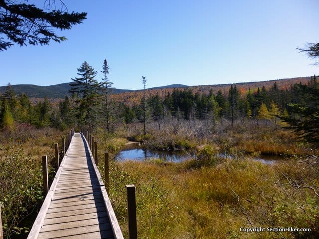
You soon enter a wetland area, where the trail crosses numerous beaver ponds over wooden walkways and bridges. The foliage here is breathtaking in Autumn, when the valley and surrounding hills explode in seasonal color.
After passing a trail junction with the A-Z Trail, the Zealand Trail ends. Continue along the Ethan Pond Trail for 0.2 miles toward the AMC's Zealand Hut. Turn right when you reach the Twinway Trail junction and continue 0.2 miles to the hut. Before you reach it, there is a short spur trail on your left to Zealand Falls which is pretty, especially after rainfall.

Drop your pack on the porch and go inside the hut to check it out. While reservations are required for overnight guests, anyone can pop into an AMC hut during the day and buy snacks, top off water bottles or use the facilities. All of the huts post daily forecasts and have weather instruments that you can check, along with maps, and guidebooks.
From the hut, continue along the Twinway, climbing steeply for 1.2 miles to Zeacliff, a cliff-side viewpoint down a short side trail (signed) overlooking Zealand Notch that has a great view of Mt Carrigain in the distance. Continue along the Twinway toward Zealand Mountain, passing another trail to your left to Zeacliff Pond, a small alpine pond, which also has a good view of Carrigain. In 1.0 miles, you'll come to another spur trail on your right which leads to the viewless Zealand Mountain summit and its hand-carved summit sign.

Retrace your steps and turn right when you reach the Twinway, heading toward Mt Guyot. Guyot (pronounced Gee-oh with a hard 'G') is a bald dome covered with low lying shrubs, called krummholz, a German word used to describe the stunted trees that grow on exposed mountain tops above treeline. The Twinway continues over Guyot and leads to the Bondcliff Trail junction. Turn left onto the Bondcliff Trail and follow it 0.8 miles to the Guyot Shelter and Tentsite Spur. I'd recommend that you stay here overnight because it the only spot with a reliable water source for some distance.

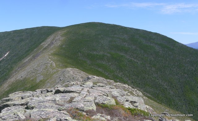
The West Bond Spur Trail leaves the Bondcliff Trail just 0.2 miles past the side trail to the Guyot Shelter and Tentsite. The open summit is a short hike through stunted trees. This is probably the best viewpoint in the White Mountains to admire Bondcliff's graceful ridge and a wonderful spot to enjoy the sunset or sunrise. Just be sure to bring a headlamp.

Backtrack to the Bondcliff Trail and turn right to summit Mt Bond in just 0.5 miles. Mt Bond also has great views. It is high enough at 4698′ that you can see the Presidential Range to the northeast and Franconia Ridge to the West.
While West Bond and Mt Bond have been easy to climb so far, the same can't be said about Bondcliff Mountain. Leaving Mt Bond, the Bondcliff Trail descends steeply down a boulder choked trail that's slow going until you reach the first open ledges on about 1 mile away. This is also a very hot section of trail in summer when the sun beating down on the rocks. Be sure to carry plenty of water and to stay hydrated. Also use caution when hiking along the cliff in fog or high winds. The steep valley below the cliffs is called Hellgate.

Midway down the cliff, there's a prow-like ledge that juts out from the cliff and is the perfect place to stand for a portrait with West Bond and Mt Bond in the background. Countless hikers have had their photos taken here and it's a right-of-passage for many 4000 footer peakbaggers
When you're ready to leave Bondcliff, proceed down the ridge towards treeline, scrambling down a 15 foot rock ledge called "Hillary's Step." I've found the best way to climb down this is backwards, so you can maintain a firm grip on the handholds. From here, the trail drops steadily back down to the Pemigewasset River passing through forest with a few easy stream crossings. These may be dry in summer, so don't count on finding water at them. Significant portions of this trail have been heavily eroded from recent storms, so take your time in descending.
Take a hard right turn at the base of the descent, continuing along the Bondcliff Trail, following an old railroad right of way. Many of the railroad ties are still in evidence to this day.

After crossing a bridge over Franconia Brook, there's a short spur trail to your right which leads to Franconia Falls, one of the most scenic waterfalls and swimming holes in the Whites. There are a series off cascades, slides, and pools here that you can frolic in or just soak your feet in the river to cool them off.

If you decide to bypass the spur trail, continue along the Lincoln Woods Trail along the Pemigewasset River, which also provide numerous swimming opportunities. Cross a suspension bridge over the river in 2.9 miles, which leads to the Lincoln Woods Trailhead and the end of this route.
Safety Disclaimer
This trip plan can not alert you to every hazard, anticipate your experience, or limitations. Therefore, the descriptions of roads, trails, routes, shelters, tent sites, and natural features in this trip plan are not representations that a particular place or excursion will be safe for you or members of your party. When you follow any of the routes described on SectionHiker.com, you assume responsibility for your own safety. Under normal conditions, such excursions require the usual attention to traffic, road and trail conditions, weather, terrain, the capabilities of your party, and other factors. Always check for current conditions, obey posted signs, and Backcountry Camping and Wilderness Area Regulations. Hike Safe and follow the Hiker responsibility code.Published 2018.
SectionHiker.com receives affiliate compensation from retailers that we link to if you make a purchase through them, at no additional cost to you. This helps to keep our content free and pays for our website hosting costs. Thank you for your support.The post A Bonds Traverse Trip Plan: Backpacking the White Mountain 4000 Footers Guidebook appeared first on Section Hikers Backpacking Blog.
from Section Hikers Backpacking Blog https://ift.tt/2KFiftR
No comments:
Post a Comment