
Mt Isolation is a remote 4000 footer located south of Mt Washington with impressive views of the Southern Presidentials and the "rock pile", as Washington is often referred to locally. This 2-3 day route follows trails seldom hiked by day hikers and is ideal for backpackers who want to experience the wilder side of the White Mountain National Forest. It visits several open summits and viewpoints en route, including Mt Crawford, Mt Resolution, Mt Davis, the Giant Stairs, which have equally impressive views. Small stream fisherman will also appreciate hiking along the avalanche-scarred Rocky Branch River, a steep-gradient mountain stream with excellent trout habitat.

Rating/Difficulty
*****/3 out of 5
Distance/Elevation Gain
25.5 miles w/6000′ of cumulative elevation gain
White Mountain 4000 Footers
- Isolation
Recommended Duration
2-3 days
Season
June thru October
Permits Required
None.
Regulations
Backcountry Camping Regulations for the White Mountain National Forest.
Most this route passes through the Presidential-Dry River Wilderness Area. Please observe all wilderness area restrictions.
Trailhead Directions
Trail Sequence
The route follows the following trails in sequence. Refer to the AMC White Mountain Trail Map 1 – Presidential Range (2017 ed), which is the best waterproof map available for this region, although I'd recommend buying the complete AMC White Mountain Waterproof Map Set (2017 ed) rather than one map at a time. More detailed trail descriptions can be found in the AMC White Mountain Guide (2017 ed), which is considered the hiking bible for the region. Take photos of the pages using your phone for easy reference, instead of carrying the entire book with you on hikes.
- Davis Path – 2.2 miles
- Mt Crawford Spur – 0.6 miles (in and out)
- Davis Path – 1.5 miles
- Mt Parker Trail – 1.0 miles (in and out)
- Davis Path 0.3 miles
- Stairs Col Trail – 1.8 miles
- Rocky Branch Trail – 4.1 miles
- Isolation Trail – 2.6 miles
- Davis Path (South) – 2.1 miles
- Mt Davis Spur – 0.4 miles (in and out)
- Davis Path (South) – 4.1 miles
- Giant Stairs Spur – 0.4 miles (in and out)
- Davis Path – 4.4 miles
Scenic Highlights
The following list provides cumulate distances on the route to each view or landmark
- Mt Crawford Summit – 2.5 miles
- Mt Resolution Summit – 4.8 miles
- Stairs Col – 5.5 miles
- Rocky Branch Shelter – 7.3 miles
- Rocky Branch River – Next 4.1 miles
- Mt Isolation Summit – 14 miles
- Mt Davis Summit – 15.4 miles
- Giant Stairs Cliff, Viewpoint, Campsite – 19.7 miles
Camping Shelter Options
- Rocky Branch Shelter #1 and Tent Platforms (lean-to which sleeps 6-8 and 3 tent platforms)
- Designated campsites along the Rocky Branch Trail, Isolation Trail, and Davis Path, indicated on the overview map provided above. While these are signed by the Forest Service, they are usually not listed on printed maps of the White Mountains so that the Forest Service can periodically relocate them to limit overuse.
Water
Natural water sources are plentiful in the White Mountains although you may need to descend to them from ridgelines along side trails if you run short. In any case, carry a detailed topographic map with you and don't rely on the overview map provided with this trip description to find water sources.
I also recommend purchasing the WMNF Presidential Range Map in Guthook Guide's New England Hiker Smartphone App (IOS, Android) which is a GPS guide to all of the trails, trailhead, shelters, campsites, views, and water sources in the White Mountains National Forest. I use it all the time and it is much more complete and current than using the maps bundled with the Gaia Smartphone App.
There is one stretch along this route where it may be prudent to carry extra water.
- One mile east of the Isolation Trail/Davis Path Trail junction to a stream just north of Giant Stairs Spur Path
Weather Cautions
This route is sensitive to seasonal and weather conditions which can make it hazardous. There are four water crossings of the Rocky Branch River on this route which may become difficult to cross in high water. The best way to avoid high water levels is to check the weather and postpone your hike if heavy precipitation is forecast during or a few days before your hike. Be sure to check the Weather.gov and Mt Washington Observatory Higher Summits forecasts before your hike.
On the Trail

After parking in the large Davis Path Trailhead, cross the Saco River over a wide suspension bridge, passing several private residences on your right, before arriving at the Davis Path sign. Built in 1845, the Davis Path is one of the oldest trails in the White Mountains, originally cut as a bridle path to bring sightseers to Mt Washington by horse.

After passing this sign, the trail begins a steep 2100′ climb up a rocky trail to Mt Crawford, passing a wilderness campsite on the right, signed with a wooden post that has a small carved tent on it. There are several such sites along this route (see overview map for locations), but they can be easy to walk past because the wooden posts indicating their presence are below knee height and colored to blend into the forest.
While the climb to Mt Crawford is admittedly steep, 1000′ per mile elevation gains are not unusual in the White Mountains trail system. Switchbacks, on the other hand are rare, so gird yourself for climbing straight uphill. When climbing, take your time and stop to rest when you need to catch your breath. Stop at level spots, as this will reduce the strain on your calf muscles. Using the rest step (read about the rest step), can also reduce leg fatigue by transferring load onto your skeletal structure and off your musculature.

As you approach the top of the climb, the trail breaks out over open rock ledge, marked by faint painted blazes and rock cairns. Most of the cairns are quite small, just a few rocks stacked one on top of the other. These are called "ducks". It's worth lingering on the ledges which have many fine views and provide a nice place to sit on a warm day. Follow the indicated path to the Mt Crawford Spur Trail and hike out to the summit viewpoint, which has fantastic 360 views. This is one of the best peaks to climb in autumn when Crawford Notch is ablaze in autumn color.

Return to the Davis Path (turning left) and continue toward Stairs Col until you reach the Mt Parker Trail on your right. Follow it for 0.5 miles over more open ledge to the summit area of Mt Resolution. While there is a summit cairn on Resolution (there are actually several), it can be hard to locate since the mountain summit is covered with short trees and shrubbery. Don't worry about it too much. If you made the effort to get here, it still counts. :-)
Reverse your route, hiking north along the Mt Parker Trail, to return to the Davis Path. Turn right and continue to Stairs Col. A col is a small mountain pass in the local vernacular, and Stairs is a wild one, with moss-covered trees and thick shrubbery. Hike east along the col to the top of the Stairs Col Trail, continuing straight, and descending down to its junction with the Rocky Branch Trail. There's a lean-to and campsite on the river here, if you want to call it a day.

Turn left onto the Rocky Branch Trail which follows the river north, crossing back and forth, several times. Most of these stream crossings are quite easy in normal conditions, provided you don't mind getting your shoes and socks wet. The river is fairly wide though, and rock hopping is often not an option. Bring a pair of crocs or water shoes if you want to keep your shoes and socks dry.

The Rocky Branch Trail was closed for several years after Hurricane Irene due to avalanches along the river bank which wiped out large sections of trail. The trail has since been repaired and in some cases rerouted. Following the trail north can still be challenging at points because this trail is in a lightly blazed Wilderness Area. The trail tread is usually easy to find and you'll always be headed in the right direction if you remember that the trail follows the river upstream.

If you're a fisherman, especially a Tenkara fisherman, you'll find that the Rocky Branch is a fun river to fish for trout. Being a mountain stream, the fish aren't big, but they are feisty! Be sure to purchase a New Hampshire fishing license if you don't already have one.
The Rocky Branch Trail meets the Isolation Trail 4.1 miles north of the Rocky Branch Shelter #1. The trail junction is on the same side of the river. and loops around the north side Mt Isolation before joining the Davis Path, which leads you to the summit. There are several additional stream crossings north of this trail junction, as well. When the trail begins heading northwest, you'll pass by two designated campsites. The first of these has easy access to water, while the second is northwest of a fairly reliable stream that crosses the trail. There are also numerous bootleg campsites along this stretch, although the two designated sites are much nicer, drier, and worth camping at if there's space.

Just before you reach the Isolation/Davis Trail junction you'll pass through an area with many downed trees, probably caused by a microburst. The trail can be tricky to follow here, so use care. When you reach the Davis Path junction turn left (south) and follow the trail to the Mt Isolation spur trail, which climbs a short distance to an open summit.
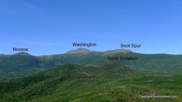
The summit of Mt Isolation is open rock ledge with wide-ranging views. The biggest mountain on the horizon is the rocky cone of Mt Washington and below it, the yawning chasm of Oakes Gulf, a deep glacial valley at the head of the Dry River. Mt Monroe is visible to Washington's immediate left. Boott Spur is to its right, a 5000+ foot subsidiary summit of Washington, located atop the southern wall of Tuckerman Ravine. North Isolation, which is a very short bushwhack, is just a short distance away, also off the Davis Path

Descend Isolation back to the Davis Path and continue south through lush forest and prime moose habitat. The next few miles of trail are seldom travelled by day hikers and quite remote. Continue south until you reach a short spur trail to Mt Davis on your left. Scramble up this trail a short distance to the summit cairn on Mt Davis. This peak, like Isolation, is an above-treeline and covered by low shrubbery called krummholz, german for twisted tree, to describe the short and gnarled trees.

Reverse your route down from Mt Davis and turn left when you reach the Davis Path. Hike south for another 4.1 miles until you reach the Giant Stair Spur Path on your left. Follow it for 0.2 miles, past another designated campsite, to a cliff face with an imposing view. Don't get too close to the edge: it really is a very steep drop!

The campsite here is a very popular spot to spend the night and view the stars. Water is very limited however, so be sure to carry in what you need.
Backtrack to the Davis Path and continue through Stairs Col toward Mt Crawford and eventually Rt 302 through Crawford Notch. This portion of the hike is identical to the beginning of the route, just in reverse. I'd still recommend hiking out to the Mt Crawford summit again. That view can't be beat.
Written 2018.
Safety Disclaimer
This trip plan can not alert you to every hazard, anticipate your experience, or limitations. Therefore, the descriptions of roads, trails, routes, shelters, tent sites, and natural features in this trip plan are not representations that a particular place or excursion will be safe for you or members of your party. When you follow any of the routes described on SectionHiker.com, you assume responsibility for your own safety. Under normal conditions, such excursions require the usual attention to traffic, road and trail conditions, weather, terrain, the capabilities of your party, and other factors. Always check for current conditions, obey posted signs, and Backcountry Camping and Wilderness Area Regulations. Hike Safe and follow the Hiker responsibility code. Disclosure: SectionHiker.com receives affiliate compensation from retailers that sell the products we recommend or link to if you make a purchase through them. When reviewing products, we test each thoroughly and give high marks to only the very best. Our reputation for honesty is important to us, which is why we only review products that we've tested hands-on. Our mission is to help people, which is why we encourage readers to comment, ask questions, and share their experiences on our posts. We are independently owned and the opinions expressed here are our own.The post A Mt Isolation Loop Trip Plan: Backpacking the White Mountain 4000 Footers Guidebook appeared first on Section Hikers Backpacking Blog.
from Section Hikers Backpacking Blog https://ift.tt/2qO5ukX
No comments:
Post a Comment