
A Presidential Traverse is one of the most famous and strenuous hikes in the White Mountains. This 2-3 day route is 25 miles in length with a cumulative elevation gain of 9,000 feet. It climbs eight 4000-footers with 14 miles of above-treeline hiking.
- Madison
- Adams
- Jefferson
- Washington
- Monroe
- Eisenhower
- Pierce
- Jackson
While many people attempt to hike this route in a single day traverse, there's a lot to be said for breaking it into a two or three day backpacking trip to savor the incredible views, camp high above treeline, and watch the stars at night. While camping above treeline is illegal, there are several inexpensive huts and tentsites along the route that are a lot of fun to stay at, in addition to the Appalachian Mountain Club's all-inclusive ($$$) huts.

- Overview GeoPDF Map (Download) [1:100,000]
- GPX File (Download) – Trails only (after downloading this file, rename it so it has a ".gpx" file extension)
Rating/Difficulty
*****/5 out of 5
Distance/Elevation Gain
25 miles w/9000′ of cumulative elevation gain
Recommended Duration
2-3 days
Season
June thru October
Permits Required
None.
Regulations
Backcountry Camping Regulations for the White Mountain National Forest, specifically no camping above treeline where trees are less than 8′ in height (except on two feet of snow) or within 1/4 mile of Huts and trail junctions.
Trailhead Directions
Appalachia Trailhead – Parking is available for about 100 cars. If the lot is full, you can park along Rt 2, however, NH state law requires that all tires be off the pavement. This is a busy trailhead that has a lot of traffic passing by, so parked cars are generally safe.
Crawford Path Trailhead – Parking is available for about 50 cars. If the lot is full, there is hiker parking across from the eastern end of pond-size Saco Lake at the top of the Notch. Do NOT park in a AMC Highland Center Lot, which is for overnight guests only.
Trail Sequence
The route follows the following trails in sequence. Refer to AMC White Mountain Trail Map 1 – Presidentail Range (2017 ed), which is the best waterproof map available for this region, although I'd recommend buying the complete AMC White Mountain Waterproof Map Set (2017 ed) rather than one map at a time. More detailed trail descriptions can be found in the AMC White Mountain Guide (2017 ed), which is considered the hiking bible for the region. Take photos of the pages using your phone for easy reference, instead of carrying the entire book with you on hikes.
- Valley Way Trail 3.8 miles
- Osgood Trail 0.5 miles (to Madison summit)
- Osgood Trail 0.5 miles (back to Madison Springs Hut)
- Gulfside Trail 0.3 miles
- Airline Trail 0.6 miles
- Lowes Path 0.3 miles
- Gulfside 2.4 miles
- Jefferson Loop 0.7
- Gulfside 3.1 miles
- Crawford Path (up to Washington) 0.2 miles
- Crawford Path (down to Monroe) 2.3 miles
- Monroe Loop 0.7 miles
- Crawford Path 1.5 miles
- Mt Eisenhower Loop 0.8 miles
- Crawford Path 1.2 miles
- Webster-Cliff Trail 0.9 miles
- Webster Cliff Trail 1.7 miles (south)
- Webster Cliff Trail 1.7 miles (north)
- Mizpah Cuttoff 0.7 miles
- Crawford Path 1.7 miles
- Crawford Connector 0.2 miles
Scenic Highlights
The following list provides cumulate distances on the route to each view or landmark.
- 3.8 miles – AMC Madison Springs Hut
- 4.3 miles – Mt Madison Summit
- 5.7 miles – Mt Adams Summit
- 6.0 miles – Thunderstorm Junction
- 8.2 miles – Edmands Col
- 8.7 miles – Jefferson Summit
- 10.3 miles – Sphinx Trail Junction
- 13.6 miles – Mt Washington Summit
- 15.1 miles – AMC Lakes of the Cloud Hut
- 15.5 miles – Mount Monroe Summit
- 18.8 miles – Mt Eisenhower Summit Cairn
- 20.2 miles – Mt Pierce Summit
- 21.9 miles – Mt Jackson Summit
Camping/Shelter Options
- USFS Valley Way Campsite (Free) – Located on a short spur off of the Valley Way Trail 3.1 miles from the Appalachia Trailhead.
- AMC Madison Spring Hut ($$$) – Advance reservations recommended
- RMC Crag Camp Hut ($) – Walk-ins only. Crag Camp is located about 1 mile northwest of Thunderstorm Junction, near to Gray Knob and The Perch. The easiest way to reach all of the RMC shelters from Thunderstorm Junction is to follow Lowes Path to treeline and to then follow protected paths to the destination of your choice. The Log Cabin is also located off Lowes Path but with more elevation loss.
- RMC Gray Knob Hut ($) – Walk-ins only. (see above)
- RMC The Perch Lean-to and Tent Platforms ($) – Walk-ins only (see above).
- RMC The Log Cabin Lean-to ($) – Walk-ins only (see above).
- USFS Hermit Lake Shelters and Tentsite ($) – Requires significant elevation loss. Purchase permit at Pinkham Notch Visitors Center.
- AMC Lakes of the Clouds Hut ($$$) – Advance reservations recommended.
- AMC Mizpah Spring Hut ($$$) – Advance reservations recommended.
- AMC Nauman Tent Platforms ($) – Caretaker in Summer. No reservations.
- AMC Highland Center ($$$) – Advance reservation recommended.
Water
Natural water sources are plentiful in the White Mountains although you may need to descend to them from ridgelines along side trails if you run short. When the AMC Huts are in season, anyone can stop in and resupply their water for free from the small sink located near the hut kitchen. In any case, carry a detailed topographic map with you and don't rely on the overview map provided with this trip description to find water sources.
I also recommend purchasing the Presidential Range Map in Guthooks Guide's White Mountains and New England Trails Smartphone App (IOS, Android) which is a GPS guide to all of the trails, trailhead, shelters, campsites, views, and water sources in the White Mountains National Forest. I use it all the time and it is much more complete and current than using the maps bundled with the Gaia Smartphone App.

Weather Cautions
This route is sensitive to seasonal and weather conditions which can make it hazardous. This is particularly true for the above-treeline portions of trip which are completely exposed to the elements. The chief hazards are high wind (above 40 mph) which can make walking difficult, rain and cold temperatures which can lead to hypothermia, being struck by lightning, and poor visibility which can make trail finding difficult if you're not a strong navigator. If the weather deteriorates or is bad, get below treeline, consider ending your trip, or changing your route to where there is more vegetation. Be sure to check the Weather.gov and Mt Washington Observatory Higher Summits forecasts before your hike. Updated weather conditions are also posted at all of the AMC Huts along the route and at the Mt Washington observatory. The weather in the Presidential Range is frequently poor and it's not unusual for experienced White Mountain hikers to postpone above-treeline trips and hike alternate, less exposed routes on bad weather days. The month with the greatest thunderstorm danger is July.
On the Trail
Leaving the Appalachia Trailhead, begin climbing the Valley Way Trail, which is the safest way to climb the treeline and one of the primary routes to Mt Madison. Valley Way in a pretty trail which passes some marvelous falls and pools near its base along Snyder Brook before veering away and climbing up to the ridge. The trail passes numerous well signed trail junctions so be sure to follow the signage carefully.
At 3.1 miles, a side path leads to the Valley Way tentsite, which is a good place to camp if you decide to spend the night after climbing Mt Madison. The campsite does not have water source and I would recommend carrying water down from Madison Spring Hut or hiking down one of the side trails a short distance to Synder Brook to get some.
The Valley Way Trail ends when it meets the Gulfside Trail, which continues another 35 yards to the AMC's Madison Spring Hut. Stop in and buy a snack or have a drink. Day hikers are welcome to come inside and have a look around or rest at the dining tables inside. You can also resupply your water at the sink next to the kitchen area.

From the Madison Spring Hut, follow the Osgood Trail 0.5 miles to the Mt Madison summit, which has excellent 360 degrees. All of the trails above treeline are marked with rock cairns and you'll want to keep on the lookout for them so you don't accidentally wander off into the boulder fields that surround the above-treeline peaks.

Retrace your steps back to the Madison Spring Hut on the Osgood Trail and turn left onto the Gulfside Trail. Follow it 0.3 miles uphill (west) to the Airline Trail. Turn left onto the Airline Trail and climb 0.6 mile to the summit of Mt Adams, the second highest 4000 footer in the White Mountains. This section of the trail runs across a boulder field, so take your time climbing it and watch your step.

From the Mt Adams summit, follow the Lowes Path Trail (0.3 miles) to Thunderstorm Junction, a huge rock cairn which is a major above-treeline crossroads.

From Thunderstorm Junction, make a left and follow the Gulfside Trail 2.2 miles to Edmands Col, which is just below Mt Jefferson, and a good place for a short rest. There's a memorial plaque here to JR Edmands, who oversaw the construction of many of the Randolph Mountain Club's trails in the Presidential Range.

From Edmands Col climb 0.2 miles and make a right onto the Jefferson Loop Trail which climbs 0.4 miles to the Jefferson Summit. Mt Jefferson is the windiest peak in the Presidential Range which is frequently blasted by prevailing winds from the west. Bad weather usually approaches from the east, so take heed if you experience a shift in wind direction.

The Jefferson Loop then descends 0.3 miles to the Gulfside Trail on Monticello Lawn, a grassy above-treeline meadow. This is one of my favorite spots on Jefferson to stop and linger. Rock cairns mark the trails here, often capped with a large piece of white rock quartz. If the visibility is poor, a compass bearing can be helpful for following the trails. You want to avoid dropping to the west off the ridgeline or the east into the Great Gulf, the huge glacial cirque below Mt Washington's north side. Don't worry, you won't encounter any sheer cliffs if you stay on the trails.

Continue along the Gulfside Trail heading South towards Mt Washington, passing the Sphinx trail on your left in 1.3 miles. The rocks on the sides of the trail sign here form a good wind break. In another 0.1 miles, you'll come to the Mt Clay Loop trail junction. Mt Clay is a 5000 foot sub-peak of Mt Washington with a great view down into the Great Gulf, the glacial valley at the foot of Mt Washington's northern head wall. If the weather is good, follow the Clay Loop Trail south. Otherwise, continue on the Gulfside Trail which converges with the south end of the Clay Loop in 1.1 miles.
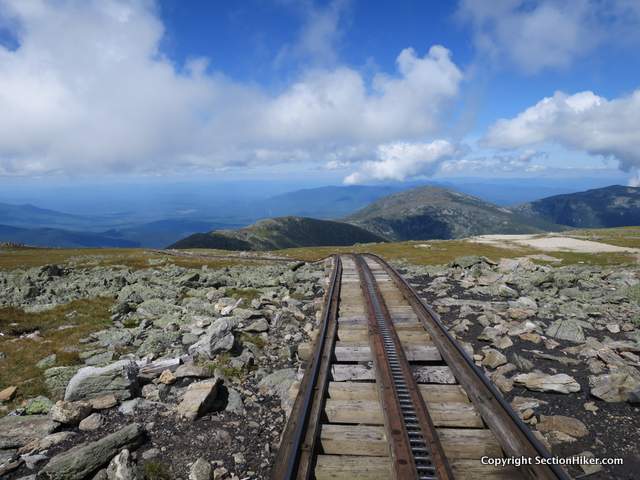
The most straightforward way to the Mt Washington Summit is to stay on the Gulfside Trail for another 2 miles until it intersects the Crawford Path. Turning left onto Crawford Path, climb 0.2 miles to the Washington summit. If you lose the Gulfside Trail before then or accidentally turn onto a smaller trail, you can follow the elevated Cog Railway Line to the Washington Summit and get back onto the route there. The Cog is a vegetable-oil powered tourist train that climbs to the summit of Mount Washington and back. You can smell its french-fry odor for miles.
Mt Washington can be a bit of a circus, because there's a road the people can drive on to get to the summit. There's also a cafeteria on the summit in season (friends recommend the chili dogs), with bathrooms and a water fountain where you can refill your water bottles. There's even a post office if you want to mail a postcard! Stop at the summit sign and get your photo taken.

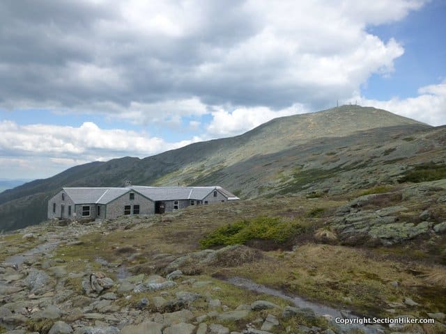
Descend Washington via the Crawford Path for 1.5, headed southwest, to two alpine tarns and the AMC's Lakes of the Clouds Hut. Even if you're not a guest, I'd encourage you to pop into the hut for a visit. There's water available here, snacks, bathrooms, and lots of information scattered around. This hut houses up to 96 guests per night and serves them two meals per day, so it's pretty cushy.
There are also weather instruments in the hut and an updated forecast posted which are worth checking before you proceed on the second half of this journey. If the wind is blowing over 40 miles per hour (hurricane force) at the hut, you're going to have a long day hiking down the Southern Presidential Range back to Crawford Notch. As the hut crew for advice if the weather is bad.
If you do need to boogie off the ridge, it's best to head down the west side rather than the east because it has better road access and requires a shorter hike out if you decide to bail. The best west-side escape routes are the Ammonoosuc Ravine Trail, the Edmands Path, and the Mizpah Cutoff/Crawford Path. There's also parking at the end of all of these trails if you decide to spot a car there.

Leaving the hut, you'll follow the Crawford Path 0.1 miles to the Monroe Loop trail, which climbs Mt Monroe and a sub-peak behind it, before rejoining the Crawford Path. Monroe an easy 350′ climb from the hut, despite the fact that it's the fourth highest 4000 footer, at 5384′. That's the beauty of a ridgeline walk and the secret to hiking multiple 4000 footers on one hike. Once you climb a ridgeline, you can pick off one peak after another, on the same hike, with relatively little incremental effort. Many of the 4000 footers are on common ridgelines and its a thrill to bag several on the same walk. If you're a purist, there are other White Mountain peakbagging lists that only credit you one peak per hike, so you can only count one at a time. Those are fun too!
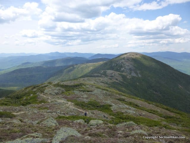
The Monroe Loop Trail rejoins the Crawford Path in 0.7 miles at a well-marked junction. Follow the Crawford Path (heading southwest) for 2.2 miles to the Eisenhower Loop Trail, which climbs another 350′ to the large rock cairn that marks the Eisenhower summit. Mt Eisenhower is named after the former US President Dwight Eisenhower, presumably because they share the same bald dome.
Continue past the Eisenhower cairn and rejoin the Crawford Path and follow it 1.2 miles to the summit of Mt Pierce, a rocky summit which juts above treeline. The views are almost continuous along this stretch, so take time to stop and day-dream.

From the summit of Mt Pierce, take the Webster Cliff Trail 0.9 miles to the Mizpah Hut, where you can also pop in for water, a bathroom break, or refreshments. Baked goods and left overs are usually available for purchase in the huts during the day and can provide a welcome break. Hint: buy the fresh-baked bread that's often available. While a big slice of bread costs money, the butter is often free, so lather it on for some extra calories.
The AMC's Nauman Tentsite is situated next to the Mizpah Spring Hut and is the only campsite along the Southern Presidential Ridge where you can camp overnight. The tentsite is overseen by a caretaker in season and a small fee is charged. You can get water at the hut.

Continue southwest down the Webster-Cliff Trail to Mt Jackson which is another knobby peak that just pokes above treeline. If you stayed at the Nauman Campsite or Mizpah Hut, or you've parked a car at the Crawford Path Trailhead off the Crawford Connector on Mt Clinton Rd, my advice would be to do a quick out and back to Mt Jackson and then resume hiking down the Crawford Path via the Mizpah Cutoff to your vehicle. This also avoids a less than inspiring road walk at the end of the hike which can be dangerous in poor weather or darkness. Jackson is also considered an optional peak on a Presidential Traverse, at least by hikers who aren't purists. But if you're already on the ridge, you might as well bag it, especially if you can't visit the White Mountains frequently.
Safety Disclaimer
This trip plan can not alert you to every hazard, anticipate your experience, or limitations. Therefore, the descriptions of roads, trails, routes, shelters, tent sites, and natural features in this trip plan are not representations that a particular place or excursion will be safe for you or members of your party. When you follow any of the routes described on SectionHiker.com, you assume responsibility for your own safety. Under normal conditions, such excursions require the usual attention to traffic, road and trail conditions, weather, terrain, the capabilities of your party, and other factors. Always check for current conditions, obey posted signs, and Backcountry Camping and Wilderness Area Regulations. Hike Safe and follow the Hiker responsibility code. Disclosure: SectionHiker.com receives affiliate compensation from retailers that sell the products we recommend or link to if you make a purchase through them. When reviewing products, we test each thoroughly and give high marks to only the very best. Our reputation for honesty is important to us, which is why we only review products that we've tested hands-on. Our mission is to help people, which is why we encourage readers to comment, ask questions, and share their experiences on our posts. We are independently owned and the opinions expressed here are our own.The post A Presidential Traverse Trip Plan: Backpacking the 4000 Footers Guidebook appeared first on Section Hikers Backpacking Blog.
from Section Hikers Backpacking Blog http://ift.tt/2FCjeZC
No comments:
Post a Comment