
A Carter Wildcat Traverse is a 2-3 day, 23 mile traverse of the entire Carter and Wildcat Mountain Ranges, including Mounts Moriah, North Carter, Middle Carter, South Carter, Hight, Carter Dome, and Wildcats A, B, C, D, and E. Hikers are treated to fantastic views of Mt Washington, The Great Gulf, Mt Jefferson, Adams, and Madison to the west and the Baldface Range to the east on this epic ridge walk.

Rating/Difficulty
****/5 out of 5
Distance/Elevation Gain
20 miles w/7500′ of cumulative elevation gain
White Mountain 4000 Footers
- Mt Moriah
- Middle Carter
- South Carter
- Carter Dome
- Wildcat (also called Wildcat A)
- Wildcat D
Recommended Duration
2-3 days
Season
June thru October
Permits Required
None.
Regulations
Backcountry Camping Regulations for the White Mountain National Forest.
Trailhead Directions
- Carter Moriah Trailhead (very limited parking – see parking recommendation below)
- AMC Pinkham Notch Trailhead and Visitors Center
This trip starts the Carter Moriah Trailhead which has very limited parking and in a Gorham, NH neighborhood. As a courtesy to the neighbors, I'd recommend parking on the gravel lot at the nearby Libby Memorial Pool (a spring fed pond) on Mill Street, about a mile south of Gorham on Rt 16. Leave the parking lot on Mill Street and turn right onto a pedestrian bridge in 0.2 miles. Cross the bridge and take a right onto Bangor Street, which quickly leads to the Carter Moriah Trailhead on your left.
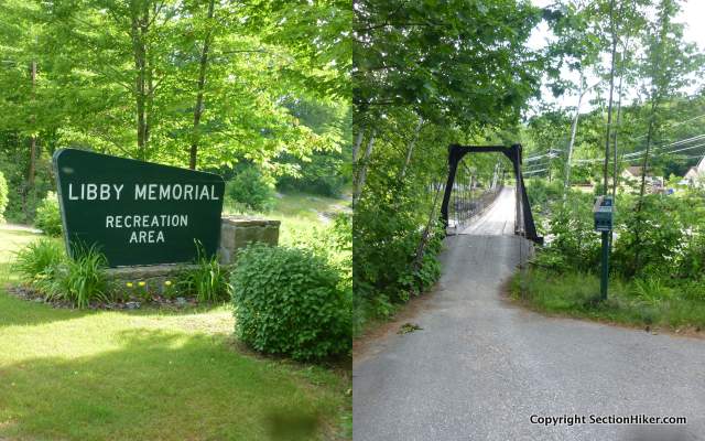
The Pinkham Notch Visitor's center, at the end of this hike, is 10 miles south of the Libby Memorial Pool on Rt 16. You can drop a second car at Pinkham or hitch back to the Libby Memorial Pool.
Trail Sequence
The route follows the following trails in sequence. Refer to the AMC White Mountains Trail Maps 5-6: Carter-Range-Evans Notch North Country-Mahoosuc (2017 ed), although I'd recommend buying the complete AMC White Mountain Waterproof Map Set (2017 ed) rather than one map at a time, because it's less expensive that way. Detailed trail descriptions can also be found in the AMC White Mountain Guide (2017 ed), which is considered the hiking bible for the region. Take photos of the relevant pages using your phone for easy reference, instead of carrying the entire book with you on hikes.
- Carter Moriah Trail – 13.8 miles
- Wildcat Ridge Trail – 4.9 miles
- Lost Pond Trail 0.9 miles
Scenic Highlights
The following list provides cumulative distances on the route to each view or landmark.
- Mt Moriah Summit – 4.5 miles
- Imp Shelter Spur Trail – 6.6 miles
- North Carter Summit – 8.5 miles
- Middle Carter Summit – 9.1 miles
- South Carter Summit – 10.4 miles
- Zeta Pass – 11.2 miles
- Mt Hight Summit – 11.8 miles
- Carter Dome Summit – 12.6 miles
- Carter Notch/19 Miles Brook Trail Junction – 13.8 miles
- AMC Carter Notch Hut 13.9 miles
- Wildcat A Summit -14.8 miles
- Wildcat D Summit – 16.8 miles
- Wildcat E Summit – 18.9 miles
- Lost Pond – 19.8 miles
Camping and Shelter Options
- Imp Lean-to and Tent Site ($) – First Come, First Served. Caretaker on duty in summer
- AMC Carter Notch Hut ($$$) – Reservations Recommended
Water
Natural water sources are plentiful in the White Mountains although you may need to descend to them from ridgelines along side trails if you run short. In any case, carry a detailed topographic map with you and don't rely on the overview map provided with this trip description to find water sources.
I also recommend purchasing the WMNF Wild River Map in Guthook Guide's New England Hiker Smartphone App (IOS, Android) which is a GPS guide to all of the trails, trailhead, shelters, campsites, views, and water sources in the White Mountains National Forest. I use it all the time and it is much more complete and current than using the maps bundled with the Gaia Smartphone App.
On the Trail

Begin climbing the Carter Moriah Trail which climbs 3250′ feet over 4.5 miles to the summit of Mount Moriah. The trail is easy to follow, but this is a significant climb so take your time in ascending. The first reliable water is at the Imp Shelter, so be sure to pack enough to get there.

At 2.0 miles you'll come to a rock ledge known as Mt Surprise which has a good view of Pine Mountain on the other side of Rt 16. From this point onward, the trail to Moriah switches from forest duff to rock ledge, gaining elevation steeply in places. Follow the signs to the Moriah Summit, a rocky knob with good 360 degree views.

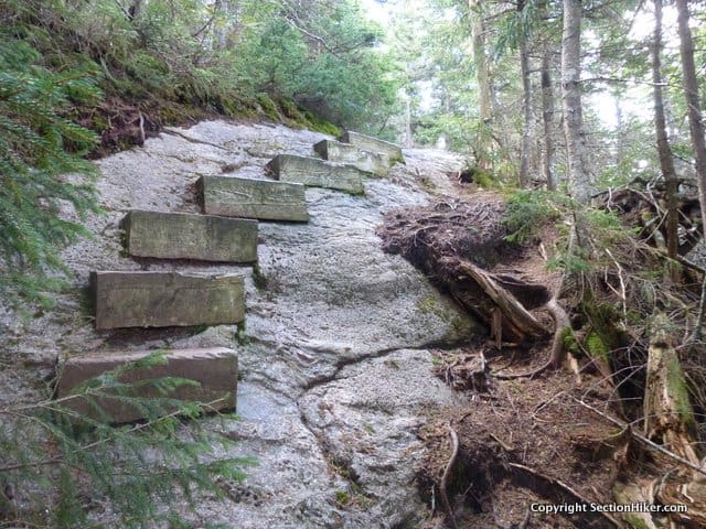
Return to the Carter Moriah Trail and turn right. In a few steps, you'll come to a rock chimney that you need to down-climb. The best way I've found to descend these is to go down backwards, like climbing down a ladder, grabbing hand and footholds as you climb down. At the base of this short chimney, turn right, continuing on the Carter Moriah Trail. From here on out, you'll be following the route of the Appalachian Trail south, marked with white blazes.

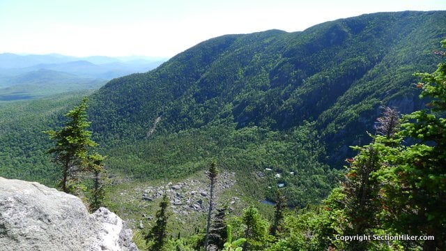
The next 1.4 miles of trail run in and out of krummholz, the stunted and weather-mangled trees, that inhabit the alpine zone. Be careful to follow the rock cairns along this section, particularly if visibility is bad in fog and mist. After a mile, you'll reach Mount Moriah's southern ledges. The trail because quite steep here and can be difficult to traverse without butt sliding if it is wet. From the ledges, you can look out across the Wild River Wilderness and into the Moriah Brook Gorge, a deep stream valley that boasts excellent waterfalls, cascades, and swimming holes. The Moriah Brook Trail is quite wild however and can be hard to follow, so you might want to hold off and explore it on a subsequent trip. See A Moriah Loop Trip Plan.
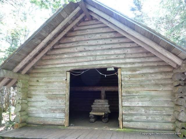
Pass the Stony Brook Trail junction, walking over boardwalk to protect the fragile vegetation at your feet. Continue for 0.7 miles until you reach the spur trail for the Imp Shelter and Tent site on your right. There's a good stream along a short path behind the shelter as well as tent platforms where you can camp. The next sure water is Carter Notch, although a small trickle may be available in Zeta Pass. Pack extra water, particularly in summer.
From the shelter, hike back to the Carter Moriah Trail, turning right towards the Carters: North, Middle, and South. The ascent up North is steep and often wet, but the Middle and South Peaks are comparatively easy to climb. The peaks are marked with cairns rather than signs, since this area borders a designated Wilderness Area. While the trail passes over Middle Carter, there is a short summit spur trail to South Carter on the right.

When you reach South Carter, you can just make out Carter Dome to the southeast. Continue along the Carter Moriah Trail for 0.2 miles, passing through an area of blown down trees, the casualty of winter storms. These have been cleared by trail crews, but there are still plenty of debris along the trail.
Zeta Pass is a major trail junction and a good place to take a rest on the rustic log bench located there. There is a very small stream, really a trickle of water flowing from the moss besides the trail, but it is intermittent and may be dry in summer. If you do need water, you can hike down the Carter Dome Trail toward the 19 Mile Brook Trail for about a mile, losing about 1000 feet of elevation to come to a stream.
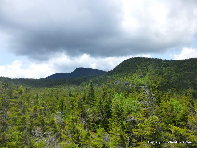
From Zeta Pass, continue along the Carter Moriah Trail to the summit of Mt Hight, which has the BEST views along the route, and some would argue the White Mountains as a whole. The summit is completely open and you can sit here for hours in fine weather gazing at the surrounding mountains to the beyond.
Return to the Carter Moriah Trail, turning left, towards Carter Dome which is just 0.4 miles away. There isn't much of a view from Carter Dome, despite the fact that it's the highest peak on the route at 4832′. The fun begins just past the summit on the steep and rocky descent into Carter Notch, dropping 1500′ in 1.2 miles. When you get to the bottom, you'll arrive at the larger of the two Carter Notch Ponds. Turn left for 0.1 miles to reach the Carter Notch Hut and right, to follow the 19 Mile Brook Trail, which climbs for 0.2 mile to the Wildcat Ridge Trail.
A notch is a mountain pass is the local parlance. The AMC's Carter Notch Hut is an ideal place to spend the night during this traverse if you'd rather sleep indoors and have your meals catered too. While advance reservations are almost always needed to stay overnight, anyone is welcome walk-in during the day to refill their water or buy snacks. Camping is forbidden in the area surrounding the hut, but you can usually find pre-existing campsites, off-trail a ways, on either side of the 19 Mile Brook Trail or the Wildcat River Trail outside the Forest Protection Area surrounding the hut.

Turn left on the 19 Mile Brook Trail onto the Wildcat Ridge Trail. The first 0.7 miles of this trail gain 1100′ of elevation as it climbs Wildcat Mountain, which is still shown on older maps as Wildcat A. The Wildcat Ridge Trail also follows the Appalachian Trail and is white blazed.
Continuing south, the Wildcat Ridge Trail runs over the B, C, D, and E peaks before descending into Pinkham Notch. While there are dips between each of the subsequent peaks on the trail, they're easier and shorter than that first climb up Wildcat A. The hardest portion of this trail is the descent from the E peak to Pinkham Notch, which drops 2000 feet in 2.1 miles. Make sure to give yourself plenty of daylight to hike down this segment of trail. I'd also recommend avoiding it altogether in wet or rainy weather because it travels down steep, unprotected sections of open ledge.

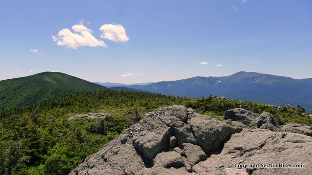
When you reach the top of Wildcat (A) Mountain, there's a fine view overlooking the notch and the pond below, on your left. Continue to the B, C, and D summit, passing over bog bridges. When you reach Wildcat D, you'll pass a wooden viewing platform at the summit, which has a fine view of Mt Washington on the other side of Pinkham Notch.

Continue past the platform down to the top of the Wildcat Mountain Ski Area and its gondola chair lift. Pass a small house (the ski area aid station), keeping it to your left and continue across a series of open rock ledges to the continuation of the Wildcat Ridge Trail, as it enters forest. The trail begins a gradual descent, then steep down a series of steep pitches and open ledge. While this section is an arduous descent, coming down it is far better than climbing up it.
When you reach the bottom of Wildcat E, turn right onto the Lost Pond Trail at the signed trail junction. It runs beside Lost Pond and an upper section of the Ellis River for 0.8 miles, passing the Square Ledge Trail on your right. When you reach a wooden bridge, cross the Ellis River, and continue along the boardwalk to Rt 16 and the AMC's Pinkham Notch Visitor's Center.
Safety Disclaimer
This trip plan can not alert you to every hazard, anticipate your experience, or limitations. Therefore, the descriptions of roads, trails, routes, shelters, tent sites, and natural features in this trip plan are not representations that a particular place or excursion will be safe for you or members of your party. When you follow any of the routes described on SectionHiker.com, you assume responsibility for your own safety. Under normal conditions, such excursions require the usual attention to traffic, road and trail conditions, weather, terrain, the capabilities of your party, and other factors. Always check for current conditions, obey posted signs, and Backcountry Camping and Wilderness Area Regulations. Hike Safe and follow the Hiker responsibility code.Published 2018.
SectionHiker.com receives affiliate compensation from retailers that we link to if you make a purchase through them, at no additional cost to you. This helps to keep our content free and pays for our website hosting costs. Thank you for your support.The post A Carter Wildcat Traverse Trip Plan: Backpacking the White Mountain 4000 Footers Guidebook appeared first on Section Hikers Backpacking Blog.
from Section Hikers Backpacking Blog https://ift.tt/2M3YAFx
No comments:
Post a Comment